
AI to help UAE get ready for extreme weather
Abu Dhabi-based Mohammed bin Zayed University of Artificial Intelligence (MBZUAI) is using artificial intelligence (AI) to conduct research to develop plans to deal with extreme weather conditions.
Following the recent record-breaking downpours that hit the UAE in April, a team of MBZUAI researchers and students combined artificial intelligence and computer vision techniques to prototype an automated analysis of satellite data to assess the likelihood of flooding.
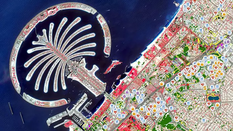
Using three localised case studies – Palm Jumeirah in Dubai, the Musaffah area in Abu Dhabi and the Al Buraimi region in Oman – the researchers used available satellite data to compare remote sensing imagery before and after a storm. The analysis aims to provide local municipalities and authorities with a useful change detection tool to quickly assess the impact of heavy downpours.
The tool can pinpoint which roads accumulate water after extreme rainfall (shown by yellow lines overlapping flood zones) and identify critically affected infrastructure such as hospitals, schools, restaurants, shopping centres and industrial complexes. In addition, the technology will help designate residential areas that may be most at risk.
The university plans to reach out to UAE government agencies such as the Abu Dhabi Environment Agency (EAD) and the Department of Municipalities and Transport (DMT), city authorities, local property developers and the UAE Flood Assessment Committee to showcase its results.
The model is currently in its early stages, and relies on AI and free publicly available data, including Sentinel-2 imagery at 10 metre resolution and OpenStreetMap, where volunteers around the world contribute geographic information – streets, points of interest and landmarks.
In the future, MBZUAI plans to expand the flood study to include more areas in the Gulf region and work with government and industry organisations to adapt and improve the tool by adding more data parameters such as existing drainage networks, location of rescue centres and 3D sensors to provide more accurate information on water levels.
Source: Gulf News
Follow our Telegram Chanel